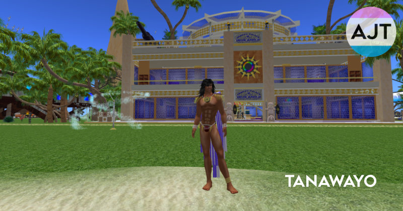

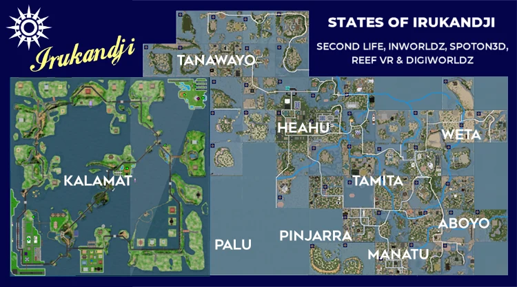
Also known briefly as Jillaroo, Tanawayo State is a sparsely populated group of simulators created by my avatar, Xay Tomsen, in the northwest of the Kingdom of Irukandji, a virtual world that has existed from 2007 to present day.
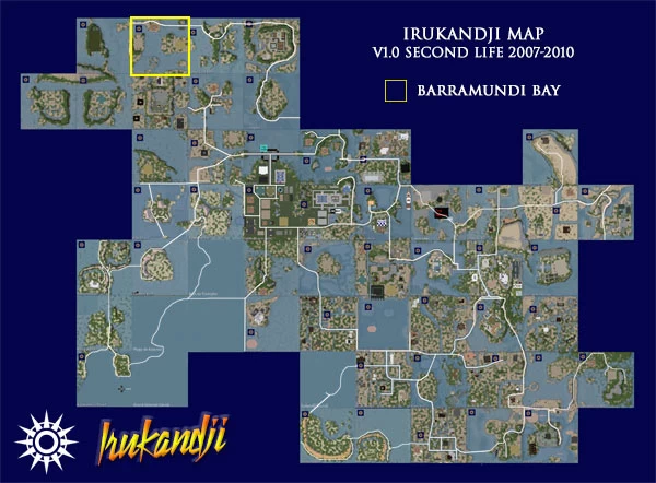
In Second Life, the regions of Tanawayo began construction in late 2007 however the GFC hit just a few months later, and given that 90% of Irukandji's population was American, most of the regions were trounced by early 2009. Sadly, another tragedy struck at the same time - the great hard-drive crash of '08 - and all but a few photographs of the state were lost forever. 😢
A few years later on the InWorldz grid, Tanawayo State existed only in an over-the-horizon sense, not in-game - You couldn't actually go there. Instead, I focused on establishing Kalamat to its immediate south, with which Tanawayo shares much of its history.
On the DigiWorldz grid however, both Tanawayo and Kalamat had an enormous presence from 2016 to 2018, occupying huge swathes of land on the new 36-square var-region, Aratura.
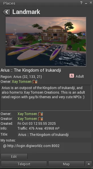
Teleport to present-day Irukandji
If you have a viewer for OpenSimulator installed, click the landmark to teleport to Arius.
History and culture ★ Tanawayo

Tanawayo vs 'the French'
The history of Tanawayo and Kalamat States are intertwined, recorded in myth and legend. In short, and to save repetition here, Irukandji went to war against the French and won. For real. Read the article, Liberation of Kalamat.
In the wake of those events, our 'invading' regions became Tanawayo, and the 'invaded' regions became Kalamat.
Islands and seas of Tanawayo
Barramundi Bay
Barramundi Bay
- Size: 6.5536 hectares
- Grid: Second Life 2008
- Use: Light Residential
Barramundi Bay is located in the far north of Tanawayo State on the Irukandji Continent.
Barramundi Bay in Second Life was light residential, sharing its southern beach with the north shore of Jackaroo Island. A long underwater section of the Trans Irukandji Causeway extends east-west from Captain Cook Reef to Tuvalu Straits.
Barramundi Bay was hand terraformed.
[ TOP ]
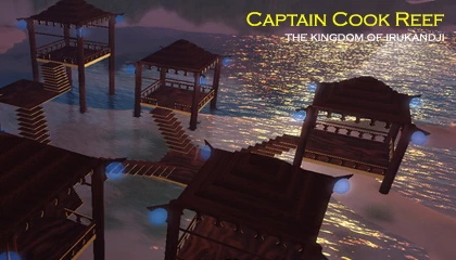
Captain Cook Reef
Captain Cook Reef
- Size: 6.5536 hectares
- Grid: Second Life 2008
- Use: Light Residential
Captain Cook Reef is a region in Tanawayo State in northern Irukandji.
Five sims adjoin Captain Cook Reef. Clockwise from east, they are Whitsunday Island, Coolangatta, Tanawayo Bay, Jackaroo Island, and Barramundi Bay.
Captain Cook Reef is a light residential sim which was popular with people seeking privacy in a remote hideaway.
The region was roughly 50-50 land and water. It featured a long Y-shaped spine of low hills running from north to south, with beaches on either side.
Housing parcels were offered on the eastern side of the hills and enjoy full occupancy.
In the east, a public tiki-style village gives a pleasant romantic feel to Captain Cook Reef, particularly at night.
Only one photograph has emerged of Captain Cook Reef but hopefully more will come to light over time.
[ TOP ]
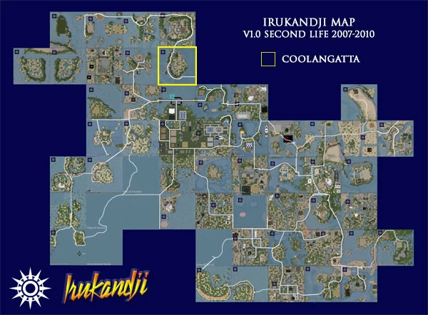
Coolangatta
Coolangatta
- Size: 6.5536 hectares
- Grid: Second Life 2008
- Use: Residential
The Coolangatta sim was part of Tanawayo State, in the north of the Irukandji Continent.
Its first landscape was as a central atoll in a bay, based on Upper Aboyo Passage. With so many regions already drawing on this design, I soon changed it into a flat atoll, based on Alantay Island, which had proved a popular format in the past.
However, the timing of Coolangatta was unfortunate. Around the time of its birth, Linden Labs, who owned Second Life, decided to suddenly increase their prices by 67%. At the same time, cut price developers on other parts of the grid had started selling land for free in some bizarre attempt to circumvent the increases by attracting lots of renters.
Coolangatta, unfortunately took the full brunt of all this. It was the first island on which I had to give land away in order to get renters. Unsurprisingly, the island quickly filled with trailer trash, predominantly Australians and Americans, who turned my manicured landscapes into shit and got ridiculously angry about the smallest thing that didn't go their way. Total haters. Then as a final nail in the coffin, along came the GFC.
So I shut down Coolangatta and a few others like it. There would be no more free land or discount islands. A new economic climate had changed the way virtual estates could operate in Second Life, and I realised the dream was coming to an end. I began to downsize in order to keep the estate viable for as long as possible.
That's all another story for another time, but the Coolangatta sim was the one that woke me up.
Coolangatta was bordered by Captain Cook Reef, Whitsunday Island, Palace Lagoon, Byron Bay, Coraki Lagoons, and Tanawayo Bay. The sim takes its name from Coolangatta, a southern suburb of the Gold Coast in Queensland AU.
I have no fond memories whatsoever of Coolangatta, and thankfully no photographs survive.
[ TOP ]
Coraki Lagoons
Coraki Lagoons

- Size: 6.5536 hectares
- Grid: Second Life 2008
- Use: Residential
The region, Coraki Lagoons is a residential island in Tanawayo State in northwest Irukandji.
Coraki Lagoons was active during 2008 and was well populated during its time on the Second Life grid.
As well as being a significant residential sim, Coraki Lagoons was an important junction of the Trans Irukandji Causeway, connecting 'old Irukandji' via Byron Bay to northern Tanawayo via Tanawayo Bay, and to Kalamat State via Aquitaine Bay.
Other adjoining sims were Split Rock Mountain, Palu Island, Mantaray Shoals, Jackaroo Island, and Coolangatta.
Unfortunately, only one photo remains of Coraki Lagoons and it isn't a particularly good one.
If you happen to have some photos of the island, please let me know.
[ TOP ]
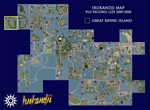
Great Keppel Island
Great Keppel Island
- Size: 6.5536 hectares
- Grid: Second Life 2008
- Use: Light Residential
Great Keppel Island is the western-most region in the Kingdom of Irukandji, and is part of Tanawayo State.
Terraforming is a direct mirror flip of the neighbouring Yeppoon Atolls sim. A single landowner leased both regions.
Only two islands adjoined Great Keppel Island. Northeast lay Tuvalu Straits, with Yeppoon Atolls immediately east.
Great Keppel Island takes its name from the real world island of the same name in Central Queensland, Australia.
The region's life was unfortunately short and no photographs survive except the aerial map above.
[ TOP ]
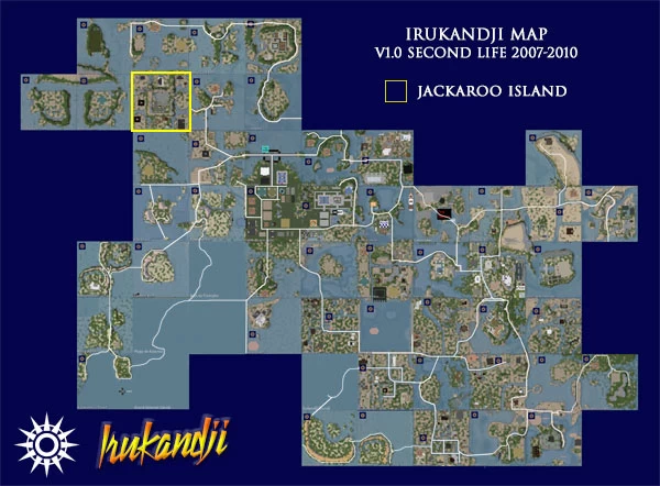
Jackaroo Island
Jackaroo Island
- Size: 6.5536 hectares
- Grid: Second Life 2008
- Use: Shops & Residential
In its earliest guise, Jackaroo Island was capital of Tanawayo State in northwest Irukandji. When I decommissioned Tanawayo in late 2008, I kept Jackaroo Island and moved it north of Cabria Island in the far east of the estate.
It sat largely unused for several months until finally, in early 2009, it was renamed Cabria Landing and sold off to another estate.
Most people however, remember it as the central island of Tanawayo.
The design and layout of Jackaroo Island was based on the much earlier and very successful Alantay Island. The uptake of land was quite healthy, and it would be the last simulator on which I was able to charge a purchase price for parcels.
Jackaroo Island was well serviced by the Trans Irukandji Causeway, and a branch of the Odin River passed through it as well. The island also had a local Irukandji Info Centre and a satellite branch of Irukandji Police.
Neighbouring sims were Tuvalu Straits, Barramundi Bay, Captain Cook Reef, Tanawayo Bay, Coraki Lagoons, Mantaray Shoals, and Yeppoon Atolls.
Regrettably, no photographs have yet surfaced of Jackaroo Island. If you happened to have visited there and took photos and wish to share them on this page, please let me know via the comment section below.
[ TOP ]
Mantaray Shoals
Mantaray Shoals
- Size: 6.5536 hectares
- Grid: Second Life 2008
- Use: Light Residential
Located in the far northwest of the Irukandji continent, Mantaray Shoals was part of Tanawayo State. The landscape was 100% original and terraformed by hand.
Mantaray Shoals was predominantly open sea with one large triangular land mass near the southwest corner. The islet contained two residential parcels.
The eastern shore of Mantaray Shoals formed the beach of neighbouring Coraki Lagoons. Clockwise from NW, the island was bordered by Yeppoon Atolls, Jackaroo Island, Tanawayo Bay, Coraki Lagoons, Aquitaine Bay, and Palu Island.
A terminus branch of the Trans Irukandji Causeway ran along the southern edge of Mantaray Shoals.
Apart from the aerial map above, it appears that no photographs survive of Mantaray Shoals. If you happened to have visited there and took photos and wish to share them on this page, please let me know via the comment section below.
[ TOP ]
Tanawayo Bay
Tanawayo Bay
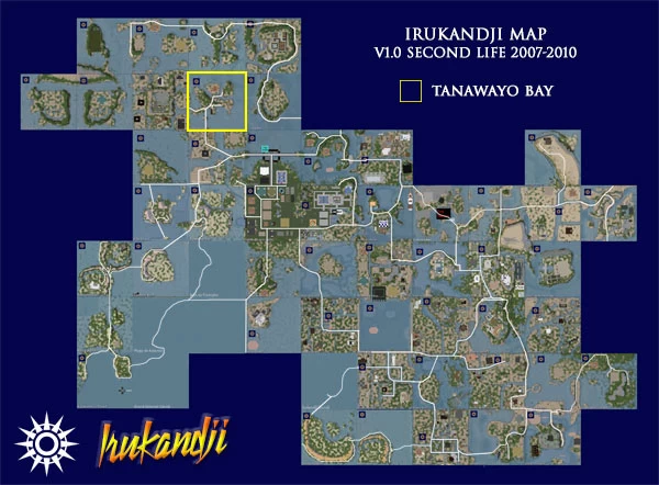
- Size: 6.5536 hectares
- Grid: Second Life 2008
- Use: Light Residential
I really liked Tanawayo Bay, and spent a lot of unnecessary time there fine tuning its terrain. Especially memorable is a technical underwater stretch of the Trans Irukandji Causeway which linked the central raised atoll to Coraki Lagoons and Jackaroo Island.
Other neighbouring regions were Barramundi Bay, Captain Cook Reef, Whitsunday Island, Coolangatta, Byron Bay, and Mantaray Shoals.
Tanawayo Bay was light residential. Three landholders from England and Mexico called the sim home, and it enjoyed 100% occupation throughout its life. Of all the 12 sims in Tanawayo, I remember Tanawayo Bay as my favourite.
Regrettably, thanks to 'the great hard-drive crash of 08', I have no photographs of Tanawayo Bay except the aerial map above.
[ TOP ]
Tuvalu Straits
Tuvalu Straits
- Size: 6.5536 hectares
- Grid: Second Life 2008
- Use: Light Residential
Tuvalu Straits was the north-western-most simulator on the Irukandji Continent.
I had originally intended to give Tuvalu Straits a mirrored companion sim to the immediate west, but demand in the region petered out when the GFC struck so it never eventuated. Regardless, Tuvalu Straits was a successful island and enjoyed 100% occupancy.
Terraforming on Tuvalu Straits was done by hand, based on an initial template copied from Upper Aboyo Passage, then rotated 90 degrees.
It appears that no photographs of Tuvalu Straits have survived. It was however a well-photographed island by locals and tourists, so I hope that some pictures surface in the future.
[ TOP ]
Whitsunday Island
Whitsunday Island
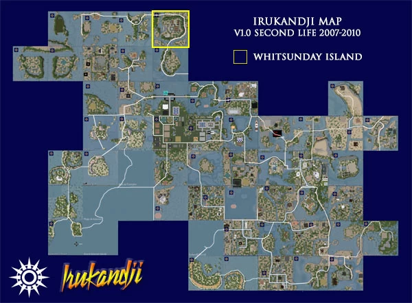
- Size: 6.5536 hectares
- Grid: Second Life 2008
- Use: Light Residential
Whitsunday Island was a residential sim in northern Irukandji.
Part of Tanawayo State, its terrain was based on the popular template I created for Upper Aboyo Passage a year earlier.
During its life, Whitsunday Island enjoyed 100% occupancy, with a Mexican landholder of long standing renting the entire island for himself and his extended family. He created a large palatial estate there which was very impressive.
The Trans Irukandji Causeway followed the crescent shaped hills that encircled the estate, connecting Whitsunday Island with the neighbouring regions, Captain Cook Reef and Coolangatta. Only one other region adjoined Whitsunday Island, which was Tanawayo Bay, only accessible by sea.
Disappointingly, no photographs survive of Whitsunday Island. If you visited there and have photos to share, please let me know in the comment section below.
[ TOP ]
Yeppoon Atolls
Yeppoon Atolls

- Size: 6.5536 hectares
- Grid: Second Life 2008
- Use: Light Residential
Located in the far northwest of Irukandji, the light-residential region of Yeppoon Atolls forms part of Tanawayo State.
While not immediately evident, the landscaping for Yeppoon Atolls actually draws heavily upon Grand Irukandji, with large canals to the east and north, overshadowed by a tall steep mountain.
Clockwise from west, Yeppoon Atolls adjoined the sims, Great Keppel Island, Tuvalu Straits, Barramundi Bay, Jackaroo Island, and Mantaray Shoals.
A single landholder leased most of the island during its lifetime until it was decommissioned in late 2008.
The simulator, Yeppoon Atolls, takes its name from the seaside town of Yeppoon in Central Queensland AU where I spent part of my childhood.
Due to hard-drive issues of the era, all photographs of Yeppoon Atolls have been lost. If you visited the region and took photos, please let me know in the comments below.